


PPGpS Lite

PPGpS Lite का विवरण
Welcome to PPGpS, a Flight Computer for Paramotor, Paraglider, Glider and Ultra Light plane Pilots
*FEATURES OVERVIEW:
-Real time flight information
-Wind direction and speed estimation
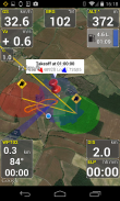
-Takeoff and Landing phases auto-detection
-Return home information (display estimated travel time and bearing)
-Fuel calculation and warning
-Emergency geo-localized SMS
-Localization with GPS
-Barometric sensor support to improve altitude accuracy
-QHN, QFE Altimeter setting
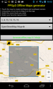
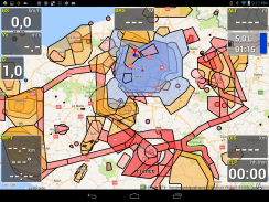
-Online and offline maps
-Offline maps creator
-Google Maps and OpenStreetMap map providers
-Rotating Map
-Log flights in KML (for Google Earth), IGC (Leonardo servers) and GPX files
-Replay recorded flights
-Waypoint management
-Especially developed for Paramotor
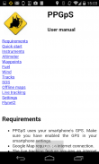
-Embedded User Manual and Tip of the day feature.
-Real time flight tracking on www.ppgps.info
-Variometer
-Sunset time
-FlyNet2 variometer support
-Flight Bandit variometer support
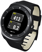
-Android Wear SmartWatch support with PPGpS Wear
*MAPS:
Online:
PPGpS can display Google or OpenStreetMap maps in connected mode.
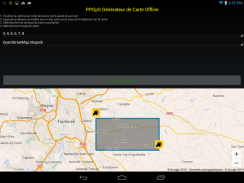
Offline:
Download map files in your smartphone in case you don't have an internet connection during the flight.
Use the integrated PPGpS Offline Map Creator to generate offline maps.
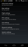
*INSTRUMENTS:
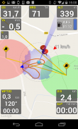
PPGpS provides the altitude, vario, bearing, magnetic compass, acceleration and ground speed.
With just one click on instruments you switch easily between different data modes : instantaneous, average and maximum values.
Altimeter can be set to actual altitude or elevation (QHN, QFE) just by long-pressing on the altimeter.
If your smartphone has a barometric sensor, it could be used to compute a very accurate altitude.
You can use PPGpS Wear companion application to display your instruments on your SmartWatch.
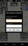
*WAYPOINTS:
Create waypoints by tapping on the map or by entering their GPS coordinates.
Select a waypoint with one click on the waypoint instrument (WPT).
Rename or remove a waypoint from the contextual menu of the waypoint list.
Follow the displayed route (bearing, estimated travel time and distance).
Prepare your waypoints from Google Earth and import your KML files (PPGpS folder in the phone).
Waypoints may be automatically loaded at startup and saved at the end of the session.
In case your KML file doesn't import well, please send me the file and I will fix it quickly.
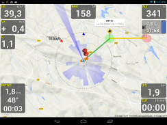
*WIND AND SPEEDS HUD:
The average ground speeds are graphically displayed for every azimuth.
The wind direction is displayed (red arrow) and may be reset at any time during the flight.
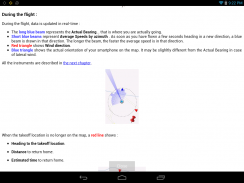
*RETURN HOME:
Home direction and Estimated Travel Time to return home is always displayed (shaded red line).
Computations are done according to the wind for accurate results.
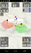
*LIVE TRACKING:
Enable the Live Tracking feature to allow your friends and family to see you live on map ! Go to www.ppgps.info for more details.
Launch the Demonstration mode to have a quick tour.
Missing features in the Lite version:
-Log flights in KML/IGC format
-Waypoints management
-QNH/QFE altimeter setting
-The annoying popups are removed in the Full version
-Display intruments on your SmartWatch
Thanks for trying it, and if it fits your needs please consider upgrading to the full version.
Visit www.ppgps.info
Find us at www.facebook.com/ppgps
and https://twitter.com/PPGpSAndroid
Enjoy your PPG flights with PPGpS and thank you for your feedback.
Don't hesitate to send me your flight kml logs by mail : stephane.nicole31@gmail.com
</div> <div jsname="WJz9Hc" style="display:none">PPGpS एक उड़ान पैरामोटर, Paraglider, ग्लाइडर के लिए कम्प्यूटर और अल्ट्रा लाइट विमान के पायलटों के लिए आपका स्वागत है
* अवलोकन फीचर्स:
रियल समय उड़ान जानकारी
पवन की दिशा और गति अनुमान
-Takeoff और लैंडिंग चरणों ऑटो का पता लगाने
-Return घर सूचना (प्रदर्शन अनुमान के अनुसार यात्रा के समय और असर)
-Fuel गणना और चेतावनी
-Emergency भू-स्थानीयकृत एसएमएस
जीपीएस के साथ -Localization
-Barometric सेंसर समर्थन ऊंचाई सटीकता में सुधार करने के लिए
-QHN, QFE Altimeter सेटिंग
ऑनलाइन उपलब्धियों और ऑफ़लाइन नक्शे
-ऑफ़लाइन नक्शे निर्माता
गूगल मैप्स और OpenStreetMap नक्शा प्रदाताओं
-Rotating मानचित्र
, आईजीसी (लियोनार्डो सर्वर) और GPX फाइलें (Google धरती के लिए) के एम एल में -Log उड़ानों
दर्ज की उड़ानों -Replay
-Waypoint प्रबंधन
खासकर पैरामोटर के लिए विकसित
-Embedded उपयोगकर्ता मैनुअल और दिन सुविधा के टिप।
Www.ppgps.info पर रियल समय उड़ान ट्रैकिंग
-Variometer
-Sunset समय
-FlyNet2 वेरिओमीटर समर्थन
-Flight दस्यु वेरिओमीटर समर्थन
PPGpS पहनने के साथ SmartWatch समर्थन पहनें -Android
* मानचित्र:
ऑनलाइन:
PPGpS जुड़ा मोड में गूगल या OpenStreetMap नक्शे प्रदर्शित कर सकते हैं।
ऑफ़लाइन:
मामले में अपने स्मार्टफोन में नक्शा फ़ाइलें डाउनलोड आप उड़ान के दौरान एक इंटरनेट कनेक्शन की जरूरत नहीं है।
ऑफ़लाइन नक्शे उत्पन्न करने के लिए एकीकृत PPGpS ऑफ़लाइन मानचित्र प्रजापति का प्रयोग करें।
* इंस्ट्रूमेंट्स:
PPGpS ऊंचाई, VARIO, असर, चुंबकीय कंपास, त्वरण और जमीन गति प्रदान करता है।
तात्कालिक, औसत और अधिकतम मान: उपकरणों पर बस एक क्लिक के साथ आप अलग डेटा मोड के बीच आसानी से स्विच।
Altimeter सिर्फ लंबे समय से दबाकर altimeter पर द्वारा वास्तविक ऊंचाई या ऊंचाई (QHN, QFE) के लिए सेट किया जा सकता है।
अपने स्मार्टफ़ोन एक बैरोमीटर का सेंसर किया है, तो यह एक बहुत ही सटीक ऊंचाई गणना करने के लिए इस्तेमाल किया जा सकता है।
आप PPGpS अपने SmartWatch पर अपने उपकरणों को प्रदर्शित करने के लिए साथी आवेदन पहनें उपयोग कर सकते हैं।
* Waypoints:
मानचित्र पर या उनके जीपीएस निर्देशांक दर्ज करके दोहन द्वारा waypoints के बनाएँ।
Waypoint साधन (WPT) पर एक क्लिक के साथ एक waypoint का चयन करें।
नाम बदलें या waypoint सूची के प्रासंगिक मेनू से एक waypoint को हटा दें।
प्रदर्शित मार्ग (असर, अनुमानित यात्रा समय और दूरी) का पालन करें।
Google धरती से अपने waypoints के लिए तैयार है और (फोन में PPGpS फ़ोल्डर) अपने KML फ़ाइलों आयात करते हैं।
वेपाइंट स्वचालित रूप से स्टार्टअप पर भरी हुई है और सत्र के अंत में बचाया जा सकता है।
आपकी KML फ़ाइल में अच्छी तरह से आयात नहीं करता है मामले में, मुझे फाइल भेजने और मैं जल्दी से इसे ठीक कर देंगे।
* पवन और गति HUD:
औसत जमीन गति रेखांकन हर दिगंश के लिए प्रदर्शित कर रहे हैं।
हवा की दिशा (लाल तीर) प्रदर्शित किया जाता है और उड़ान के दौरान किसी भी समय रीसेट किया जा सकता है।
* घर लौटना:
होम दिशा और घर लौटने के लिए यात्रा अनुमानित समय हमेशा (लाल रेखा छायांकित) प्रदर्शित किया जाता है।
संगणना सटीक परिणाम के लिए हवा के अनुसार किया जाता है।
* लाइव ट्रैकिंग:
आप नक्शे पर रहते हैं को देखने के लिए अपने मित्रों और परिवार की अनुमति के लिए लाइव ट्रैकिंग सुविधा सक्षम करें! अधिक जानकारी के लिए www.ppgps.info पर जाएं।
एक त्वरित दौरे के लिए प्रदर्शन मोड लॉन्च।
लाइट संस्करण में सुविधाओं लापता:
के एम एल / आईजीसी प्रारूप में -Log उड़ानों
-Waypoints प्रबंधन
-QNH / QFE altimeter सेटिंग
-इस कष्टप्रद पॉपअप पूर्ण संस्करण में हटा रहे हैं
अपने SmartWatch पर -Display intruments
यह कोशिश कर रहा है, और यह अपनी आवश्यकताओं फिट बैठता है अगर पूर्ण संस्करण के लिए उन्नयन पर विचार कृपया के लिए धन्यवाद।
Www.ppgps.info जाएँ
Www.facebook.com/ppgps पर हमें पता लगाएं
और https://twitter.com/PPGpSAndroid
PPGpS के साथ अपने PPG उड़ानों का आनंद लें और आपकी प्रतिक्रिया के लिए धन्यवाद।
मेल के द्वारा मुझे अपनी उड़ान KML लॉग्स भेजने में संकोच न करें: stephane.nicole31@gmail.com</div> <div class="show-more-end">
PPGpS Lite - Version 1.59a
(30-05-2021)
PPGpS Lite - एपीके जानकारी
एपीके संस्करण: 1.59aपैकेज: com.ppgps.liteLatest Version of PPGpS Lite
अन्य संस्करण


Apps in the same category


